GeoScan

Spatial Country Profile

GeoScan provides IFAD with timely and accurate geospatial data for evidence based country strategy planning, project design, monitoring and evaluation.

Gathering, analysing and presenting data for socio-economic indicators, environmental variables, and climate or disaster data is complex, time-consuming and requires a specialized skill-set.

Geo-scan provides a user-friendly solution through an intuitive platform that transforms complex data into useful and automated products: ready to use maps, statistics, web applications and stylish GIS tools.

“It was not just interest people expressed about GeoScan, it was like a dam about to burst!”

David Hughes (ICT Solutions Coordinator)

Feedback received during a GeoScan presentation at the Asian and Pacific Retreat (APR) in South Korea 2019.

RESULTS ACHIEVED

  • Literature review and report on 132 global, 72 regional and 150 thematic data sources
  • Data model with key themes in environment, socio-economic indicators, climate, etc
  • Data processing and automation of 110+ standardized GIS layers in various themes
  • Dynamic and up-to-date spatial data for 19 countries across all IFAD regions based on user demand and 2020 COSOPs
  • Development and implementation of 19 web and 19 desktop GIS applications
  • 19 ready to use digital atlases with country reports in PDF format and 70+ predefined automated maps/reports
  • Mobile app prototype

POTENTIAL IMPACT

  • Increased connectivity by allowing users to take data “off the grid” in the field or with third party partners
  • Low cost scale up and compatible with Enterprise GIS platform
  • Increased efficiency by integrating and automatically processing multiple data sources
  • State-of-art interoperability with the latest and most reliable geospatial data and analytic service providers
  • Enhanced inter-department partnerships, including with non-GIS users
Mobirise

Recommendations for next steps (from the project team)

Advanced (scaled up)

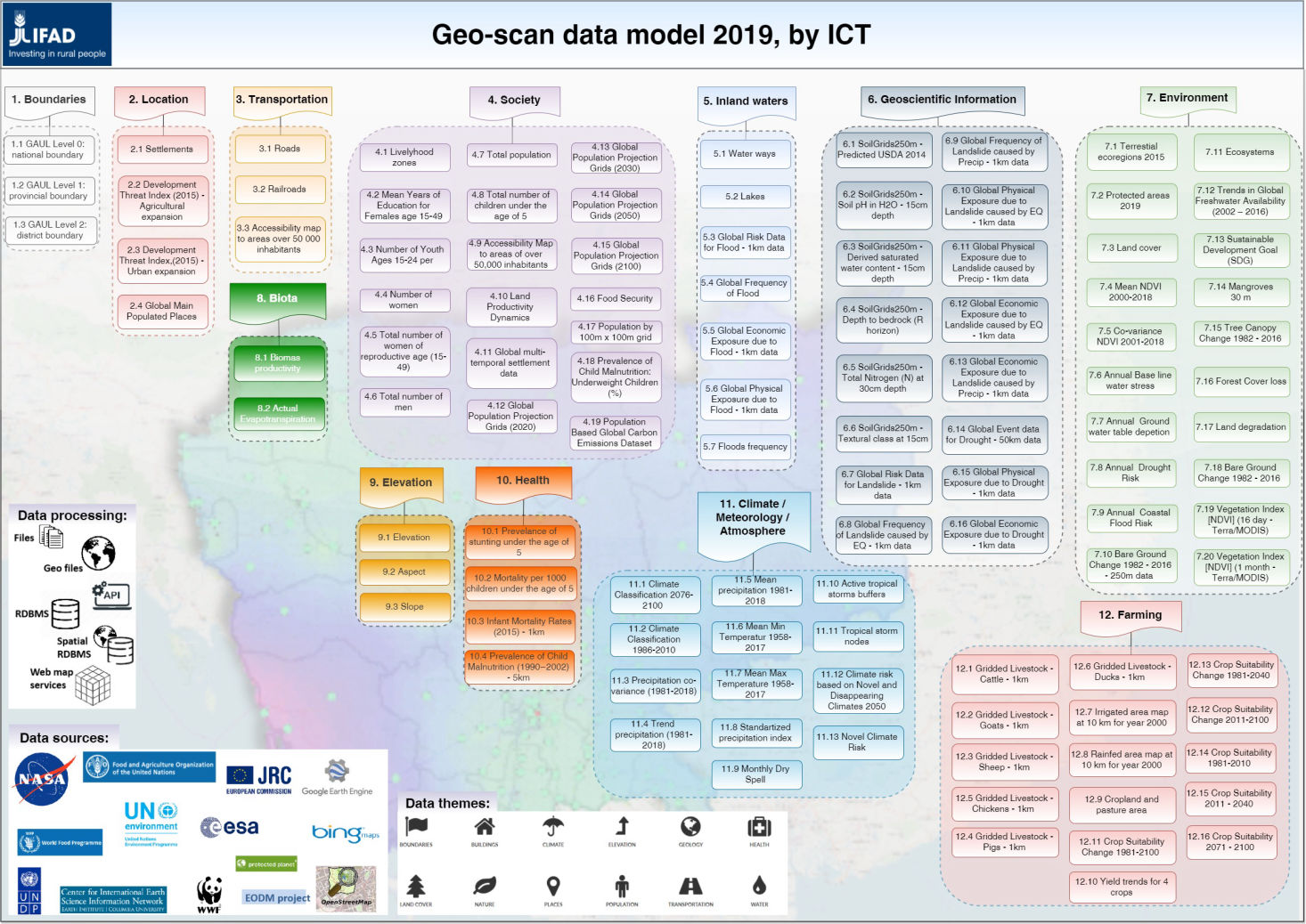
Through this project, it became clear there is demand for this solution. The original design we planned to include 15 countries, but this grew to 19 based on user demand. Country programme managers have already expressed interest in training on the deliverables and implementation of GeoScan for all countries within IFAD’s largest region. GeoScan also presents an opportunity to build up the data model with SECAP related needs and the project design process, as well as to enhance our transparency in decision-making.

Mobirise

Lessons learned (from the project team)

The Innovation Challenge helped us bring together a good plan, good team and clear vision with freedom to explore what we promised. We had the opportunity to learn from our mistakes and test different platforms, tool sets and options. We worked in iterations and by accepting that failure was part of the process, we learned much more. We also learned it is essential to set up a good team and that sometimes you need to show users what they need. Throughout the whole process, we built tremendous knowledge, documented it well for future reference and had fun. 

© Copyright 2021 International Fund for Agricultural Development (IFAD)

The page was started with Mobirise themes