Tracking investments in Tunisia with remote sensing
Tracking investments in Tunisia with remote sensing

Many elements involved in IFAD-funded projects – from man-made structures like roads and buildings to natural features such as forested areas – are visible from space. As long as an element’s precise geographic coordinates are known, satellite imagery can be used to monitor any changes that have taken place.
As part of the PRODEFIL project in Tunisia, for example, over 140 km of road have been constructed. Checking the entire length of these roads in person would have taken two days. Checking it via Google Earth, however, took only a few hours.
Other sites that the project has invested in, such as dams and greenhouses, are also visible via satellite. High-resolution imagery makes it possible to track the development of these and other types of investments, including irrigation schemes and reforestation efforts.
Using earth observation technology to detect changes in this way is a cost-effective and time-saving option for monitoring large areas and multiple sites. Although it cannot replace field visits or engaging with project participants, it is especially useful for tracking and evaluating the impacts of project activities in areas that are remote or not accessible – for example, due to conflict or in times of travel restrictions.
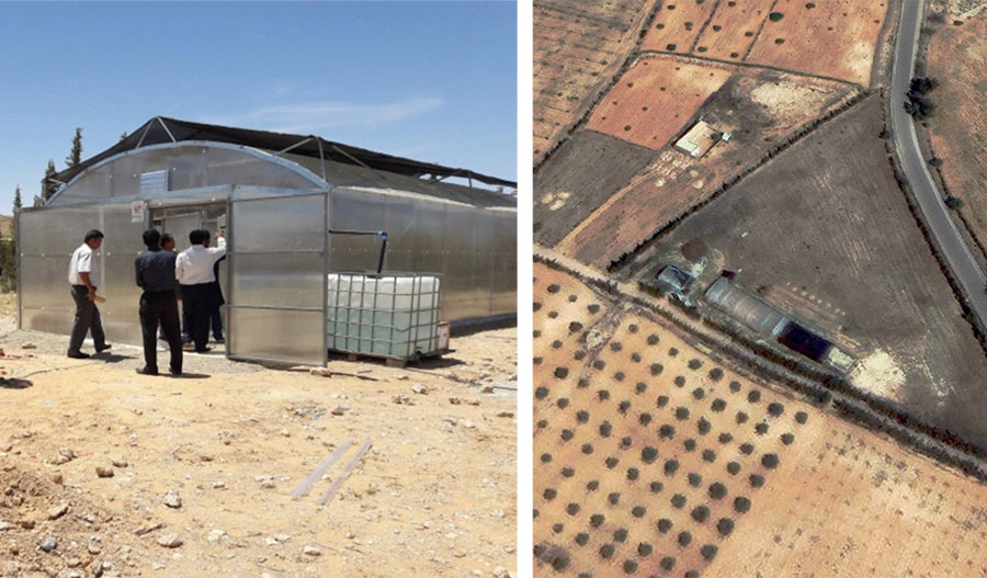 |
| Left: A greenhouse built by the PRODEFIL project in the municipality of Beni Khedache, taken on location (© PRODEFIL). Right: The same structure as seen via satellite (© Maxar Technologies). |
Mapping investment sites is essential
For remote observation of this kind to take place, geospatial data (also called GIS data) must first be collected from the investment sites. Without knowing the exact location, analysts cannot know where to look for change or may detect change that is not due to the project activities.
In terms of mapping IFAD investments, GIS data come in three different flavours: polygons depict areas (e.g., irrigated farmland); polylines display transecting elements (e.g., roads); and points denote standalone locations that have coordinates (e.g., a warehouse). Although these kinds of data can be captured using a smartphone or tablet, specialized GPS devices should be used whenever possible because they are more accurate. To facilitate analysis, the type of investment and other variables (e.g., the dates on which various activities were started or completed; whether a project is new or a rehabilitation) should also be recorded.
Over 60 IFAD-funded projects already collect GIS data on their activities to varying degrees. Engineering contractors, for example, often take GIS measurements when designing elements of infrastructure. Nevertheless, IFAD should begin to collect these data more systematically to facilitate remote monitoring and evaluation.
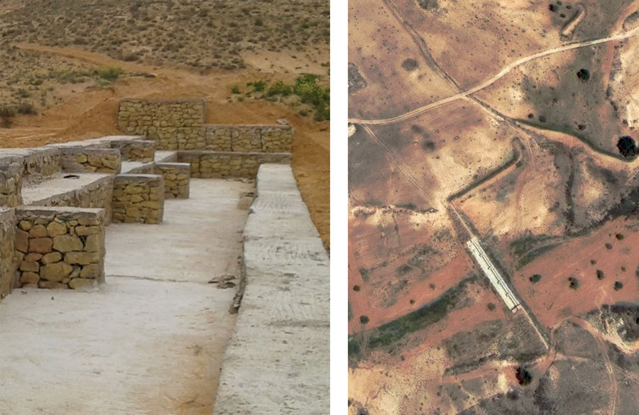 |
| A dam for groundwater recharge built by PRODEFIL in the municipality of Beni Khedache, as seen in photos taken on location (left, © PRODEFIL) and by satellite (right, © Maxar Technologies). |
Plotting investment sites against satellite imagery
Once a location has had its spatial dimensions measured, its coordinates can be used to locate it on satellite imagery. Quick and simple analysis (as done with the roads constructed as part of PRODEFIL) can be done with free, user-friendly tools such Google Earth or Global Forest Watch, which give users access to a small set of high-resolution imagery.
More sophisticated analysis requires GIS and earth observation expertise to know where to find suitable imagery and how to process it. Analysts use a variety of specialized software programmes, ranging from processing platforms like Google Earth Engine, to mapping software such as QGIS, to statistics programmes such as R, to achieve detailed results.
Satellite imagery providers often have one or more portals where data can be downloaded or otherwise accessed via the cloud. The biggest freely available archives of medium- and high-resolution data, including MODIS, Landsat, and Sentinel (part of the European Space Agency’s Copernicus Programme), offer images in a wide range of resolutions. Many of them have data banks stretching back years or even decades (in Landsat’s case, to the 1970s).
For more sophisticated analysis, though, much higher-resolution imagery is needed. Providers such as AIRBUS, Digital Globe and Planet offer very high-resolution imagery (down to 20 centimetres). The cost for this imagery depends on the scale, resolution, and timespan needed. A number of these service providers also specialize in detecting change over time.
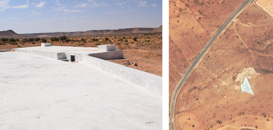 |
| A water cistern under construction in the municipality of Beni Khedache, as seen in photos taken on location (left, © PRODEFIL) and by satellite (right, © Maxar Technologies). |
Mapping the exact locations of investment sites has been invaluable for the PRODEFIL team to be able to implement its activities and for IFAD to supervise the project. Other IFAD-supported projects in Tunisia are now mapping their activities as well. IFAD is using these data not only for change detection but also as a component of project impact assessments to help evaluate the project’s success.
Other United Nations agencies are also using these technologies. WFP’s AIMS service, for example, uses satellite imagery and landscape monitoring techniques to evaluate some of its project activities, including those involving infrastructure development and landscape restoration.
Earth observation has its limitations. Satellite imagery data is limited over areas with persistent cloud cover. Certain activities (e.g., a rehabilitation of a small bridge or culvert) may be too small or subtle to be detectable. And very high-resolution imagery can be costly. Nonetheless, the combination of GPS location information and satellite imagery offers project planners, managers and evaluators an increasingly powerful tool to improve the effectiveness of development investments.
For more details on our remote-sensing activities in Tunisia, check out the full case study.
Acknowledgements: Thanks to Mounir Ben Ameur and the rest of the PRODEFIL project team for providing the GIS data and photographs.
Publication date: 23 February 2021